
- Book Signing at Bailey H. Dunlap Library
- Young Author Selene Olguin Continues Local Book Tour
- La Feria Community Holds Succesful Business Mixer Event
- Little Nashville to Take Place in Downtown Mercedes
- Lions Basketball Captures District Gold
- La Feria ISD Students Compete in Regional Chess Tournament
- Lions End First Half of 32-4A on a High Note
- La Feria ISD Held Another Successful Parent Conference
- Strong Appearance for Lions at Hidalgo Power Meet
- LFECHS Students Get to Meet Local Actress
Valley Prepares for Hurricane Season
- Updated: July 19, 2013
An Active Tropical Storm Season Forecast
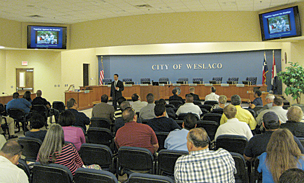
Steve Drillette makes point during Hurricane Awareness and Preparation Seminar. Photo: Bill Keltner/LFN
Steve Drillete, Meteorologist-In-Charge for the National Weather Service and National Oceanic and Atmospheric Administration in Brownsville, told a capacity crowd of first-responders to be ready for an active 2013 hurricane season. He made his sobering remarks during the RGV Hurricane Partners and Integrated Warning Meeting in the City of Weslaco’s Legislative Chambers. Steve Drillete and Barry Goldsmith, NWS/NOAA Warning Coordination Meteorologist, shared the day-long program.
The meeting was directed to Valley first emergency responders, medical support people, and law enforcement agents. It provided an up-dated tropical storm forecast and a review of the enhanced services the NWS will be providing should one of this year’s 12-20 named storms target the lower Texas coast during the 2013 hurricane season.

NWS Meteorologist-in-Charge, Steve Drillette personally welcomed the invited guests to the Emergency Hurricane meeting.
Drillette set the tone for the meeting with his question: Why Are We Here? He promptly answered it. “We are here to build partnerships in preparation for the 2013 hurricane season beginning this month and ending in November,” he said. “We are concerned with making people aware of the dangers of tropical storms in the Gulf of Mexico and Atlantic, so they can be prepared.”
The top meteorologist reviewed the history of tropical storms along the Texas coast since the 16th century. “There are some weather patterns that are very useful to the National Weather Service in our predictions,” he said.
Weather records list memorable un-named, historic storms tracing from the devastated colony of Indianola and the monster storms that struck Freeport, Galveston and Corpus Christi over the years. Named storms within the memory of many present, brought back bitter memories– Among them: The Category-5 storm Carla in 1961 with a 22-foot storm surge at Port La Vaca, and Beulah in 1967 that struck the Valley. It was also a Cat-5 storm with 688 deaths, flooding and over 100 tornados. That well-documented 1967 storm was one of the worst to touch the Texas coast and is still studied by meteorologists. “That storm had an 18-foot surge in Willacy county, Drillette said for emphasis.”
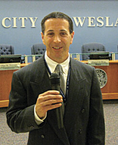
NWS Warning Coordination Officer, Barry Goldsmith, forecasts the 2013 Hurricane Season.
Douglas Butts, NWS Science and Operations Officer, gave an update on the 2013 hurricane season. He said right now the Atlantic, Caribbean and Gulf are in a kind of a “neutral position” between the influences of El Nino and La Nina, weather systems from the Pacific that affect our weather. “Neither one is driving the tropical weather at present.,” he said, adding, “But because of other factors in the Atlantic basin,, we are predicting up to 19-20 this year—five could touch land somewhere.”
Barry Goldsmith gave the 2013 Seasonal Forecast, and what it means for us. “Everyone is concerned about “the Big One” making landfall again like Beulah–will this be the year?” he said. Then he said, even with the North American and European Models, “We can only predict two-three weeks out—If I could predict out beyond that, I’d be a billionaire,” he told everybody quite frankly.
City of Weslaco hosts meeting in their new Legislative Chambers.
Then he said, to the best of our knowledge at this moment, “The Northwest Gulf is quiet and has been for some time, therefore, again he qualified his prediction, the probability of a “Big one” on the Texas coast is low for a direct hit. Most of the storms during the past couple of years have formed in the Caribbean and Gulf and turned to the Northeast; we expect that to continue.”
“However,” he added, “it only takes one hurricane to make a season memorable—remember that Beulah was only the second storm of that season, and came in mid-September.”
“But,” he warned, “Don’t believe every long-range seasonal forecast because unforeseen factors can and do happen that can suddenly and drastically alter a prediction,” he said. He listed Jet Stream weather pattern changes and “wind shear” aloft from northern fronts, some 25,000 to 36,000 feet. Another “wild card” affecting seasonal predictions is the water temperature in the Gulf of Mexico and Southern Oscillation in the Atlantic.
NWS Meteorologist-In–Charge, Steve Drillette, assured those present that the Brownsville office of the National Weather Service will provide a “Cone of Warning” and a “Track projection” to the public by radio and television to help make intelligent decisions in the face of possible disaster. For further information, call: (956) 572-1492.
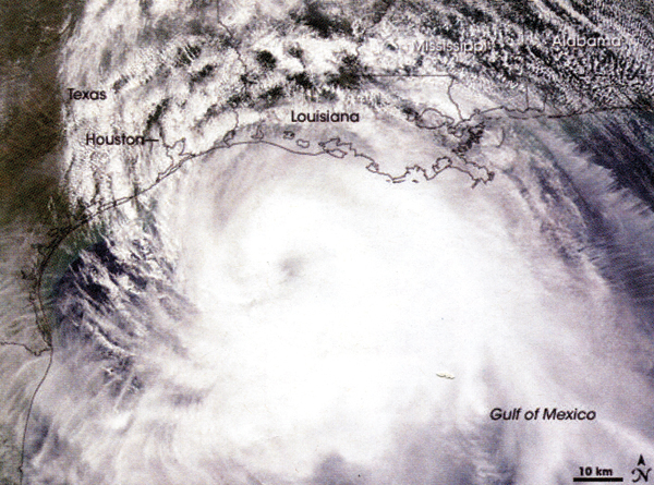
High resolution satellite image of Hurricane Ike over the northwest Gulf of Mexico. Since 1851, 63 hurricanes have struck the Texas coast at an average of one every three years. Photo: NASA